


![]() Press release
Press release
267KB
Comunicato Stampa disponibile solo in lingua originale.
On 24 August, an earthquake struck central Italy, claiming at least 290 lives and causing widespread damage. Satellite images are being used to help emergency aid organisations, while scientists have begun to analyse ground movement.
The Italian peninsula is prone to earthquakes owing to the fault lines created by the separation of the African and Eurasian tectonic plates. The fault line separating these two plates runs below the central Apennine mountains and along Italy’s Adriatic coast.
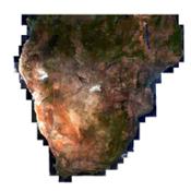
Under the coordination of the Italian Department of Civil Protection, scientists from Italy’s National Institute for Geophysics and Volcanology and the Institute for Electromagnetic Sensing of the Environment of the National Research Council are studying data from the Sentinel-1 satellite mission and other spaceborne radar missions to map surface deformations caused by the earthquake.
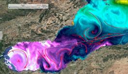
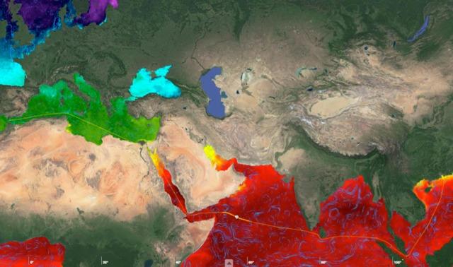
The team found that the main deformation pattern shows subsidence reaching about 20 cm in the Accumoli area, and sideways movement of up to 16 cm.The scientists use a technique that allows them to map surface deformations by comparing radar images over the affected area taken before and after the event.
The team has benefited from the availability of both Sentinel-1A and Sentinel-1B scans. The scientists were able to quantify the ground movement in both vertical and east–west directions by combining the radar scans obtained as the satellites flew both south to north and north to south.
Sentinel-1 is not the only satellite providing information on this recent quake: scientists are also relying on data from the Italian space agency’s Cosmo-SkyMed satellites, as well as satellite imagery from other space agencies.
In addition, data from a multitude of Copernicus contributing missions are being used to produce maps through the Copernicus Emergency Management Service for damage assessment.
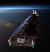
Sentinel-1 is a two-satellite mission for Europe’s Copernicus environment monitoring programme, led by the European Commission. The first satellite – Sentinel-1A – was launched in 2014, while its sister Sentinel-1B is still in its commissioning phase following launch just four months ago.
With its 250 km-wide swatch over land surfaces, Sentinel-1 gives scientists a broad view of the displacement, allowing them to examine the ground displacement caused by this earthquake and develop the scientific knowledge of quakes.
Once Sentinel-1B is operational next month, it will be possible to perform routine scans over critical areas like Italy every six days with the two-satellite constellation.

Ground displacement from Italy s earthquake
![]() 3959x2826, 5MB
3959x2826, 5MB
Italy earthquake deformation
![]() 4444x4680, 7MB
4444x4680, 7MB
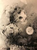
Source fault of Italy s earthquake
![]() 1378x1111, 691KB
1378x1111, 691KB
![]() Press release
Press release
267KB
News correlate |
||
|
|
|
aprile 13, 2017
|
marzo 24, 2017
|
marzo 24, 2017
|
|
Comunicato Stampa disponibile solo in lingua originale. With around 90% of world trade carried by ships, making sure a vessel foll... |
Comunicato Stampa disponibile solo in lingua originale. With the pair of Sentinel-2 satellites now in orbit, users are looking ahe... |
Comunicato Stampa disponibile solo in lingua originale. From 27 February to 17 March 2017, Aoife van Linden Tol, a multimedia arti... |
Ti potrebbe interessare anche |
||
|
|
|
marzo 23, 2017
|
marzo 16, 2017
|
marzo 06, 2017
|
|
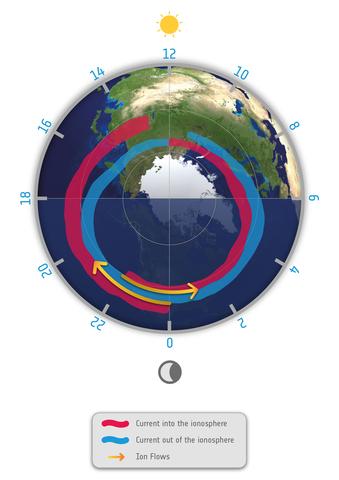
Information from ESA’s magnetic field Swarm mission has led to the discovery of supersonic plasma jets high up in our atmosphere t... |
Quarantadue è la risposta, ma quale è la domanda? Gli scienziati dell'Università di Zurigo hanno voluto sondare come le cellule im... |
Comunicato Stampa disponibile solo in lingua originale. Vloggers recently spent two days at ESA’s astronaut centre to prepare for ... |
© Copyright 2024


 Inglese
  Condividi
 Condividi via mail
  Automotive
 Sport
Sport Events
 Art&Culture
 Design
 Fashion&Beauty
 Food&Hospitality
 Tecnologia
 Nautica
 Racing
 Excellence
 Corporate
 OffBeat
 Green
Green Gift
Gift Pop
Pop Heritage
 Entertainment
 Health & Wellness